You are using an out of date browser. It may not display this or other websites correctly.
You should upgrade or use an alternative browser.
You should upgrade or use an alternative browser.
Garmin Oregon 550
- Thread starter ferbikes
- Start date
guerracerdeira
New Member
Se os pontos já estão no GPS basta criar uma rota e ir seleccionando-os, se não, tem de os copiar do PC para a pasta GPX, do GPS ou do cartão de memória, e depois criar a rota com eles.
Existem também vários programas que permitem faze-lo no PC e depois exportar para o GPS.
Ajudou alguma coisa?
Abraço.
Existem também vários programas que permitem faze-lo no PC e depois exportar para o GPS.
Ajudou alguma coisa?
Abraço.
Guerra obrigado por ajudares mas vou refazer a questao... Vou participar no www.titandesert.es e é-nos facultado um roadbook e coordenadas dos Pontos de Control e Posto de Abastecimento... O que quero aprender é a inserir as coordenadas dos Pontos de Control para depois orientar-me em direcçao ao proximo control... Assim o que quero é inserir 3 ou 4 coordenadas e eu definir que caminhos seguir...
Obrigado e espero ter-me explicado melhor...
Abraço
Obrigado e espero ter-me explicado melhor...
Abraço
guerracerdeira
New Member
No Mapsourse é directo, Edit, new waypoint, dar nome, coord., etc.
No Oregon, por ex., Para Onde?, Coordenadas, introduzir coordenadas, depois mudar nome e está feito.
Como disse há vários programas livres que permitem fazer isso na maior das calmas e depois passar para o GPS.
Abraço
No Oregon, por ex., Para Onde?, Coordenadas, introduzir coordenadas, depois mudar nome e está feito.
Como disse há vários programas livres que permitem fazer isso na maior das calmas e depois passar para o GPS.
Abraço
Boas!!! E desde ja obrigado pelo esclarecimento.... Ja consegui, com uns erros aqui outros ali mas tentando e la se vai... Será que podes tirar-me outra duvida???? Isto de ser azelha é o que dá...
Quando recebo tracks por mail, tendo já o Garmin BaseCamp instalado no pc de que forma passo do mail para o aparelho gps... deve ser facil mas eu.... Obrigado e um abraço!
Quando recebo tracks por mail, tendo já o Garmin BaseCamp instalado no pc de que forma passo do mail para o aparelho gps... deve ser facil mas eu.... Obrigado e um abraço!
guerracerdeira
New Member
Boas,
Os Garmins actuais reconhecem ficheiros de tracks com extensão GPX, CSV e GPI.
Desde que os tracks que recebes-te tenham uma destas extensões podem ir directo para a pasta Garmin\GPX quer da memória interna, quer do cartão, atravéz do PC.
Para ser sincero eu uso pouco os programas da Garmin à excepção do WebUpdate e do Mapsourse.
Abraço.
Guerra
Last edited:
Honda
Peço desculpa a demora à tua pergunta mas não tenho tido muito tempo para explorar bem esta maquina do GPS. Mas respondendo à tua pergunta não, não faço Geocaching, nem sei bem do que se trata. Mas agora em melhorando o tempo tou a pensar começar a tirar partido disto até porque o investimento não foi barato.
Obrigado pela tua ajuda e no que poder ser util dispoe embora neste ramo do GPS sou apenas principiante.
Abraço e boas pedaladas.
De nada, qualquer coisa tás à vontade, nem que seja para umas pedaladas com umas caches pelo meio
")
Abraço
Nelson
Boas,
Os Garmins actuais reconhecem ficheiros de tracks com extensão GPX, CSV e GPI.
Desde que os tracks que recebes-te tenham uma destas extensões podem ir directo para a pasta Garmin\GPX quer da memória interna, quer do cartão, atravéz do PC.
Para ser sincero eu uso pouco os programas da Garmin à excepção do WebUpdate e do Mapsourse.
Abraço.
Guerra
Eu só uso o WebUpdate.
Já que falamos nisso... recomendo a quem tenha o Oregon que trate de fazer um Update porque há bastantes novidades.
>>>>>>>>>>>>>>>>>>>>>>>
Changes from version 3.00 to version 3.10:
Increased the map drawing range to allow maps to draw farther south.
Corrected issue with route line sometimes not drawing.
Corrected issues with marine POI.
Corrected issues with GB Discoverer maps.
Corrected issues with possible corrupted profile showing on the Profile Change page.
Corrected issue with project waypoint bearing sometimes not showing the input value.
Changes from version 2.70 to version 3.00:
Added ability to view elevation plot of upcoming active route or currently navigated track in blue.
Added display of icons to the lists in Where To? > Waypoints and the Geocaching application.
Added phone numbers when available to POI review pages.
Added Compass, Stopwatch, Active Geocache, and Elevation Plot dashboard options.
Introduced dashboard options to the Compass and Map pages.
Improved track navigation. Visit http://garmin.blogs.com/softwareupdates/trail-tech/ for more information.
Changes from version 2.60 to version 2.70:
Added profile support for Garmin Custom Maps
Fixed lockup while using GB Discoverer maps
Changes from version 2.30 to version 2.60:
Added support for Garmin Custom Maps
Added heading to geotagged photo EXIF information (see GPSImgDirection and GPSImgDirectionRef tags)
Improved along road routing performance
Improved support for importing geotagged photos to various desktop applications
Corrected issues causing some geotagged photos to be drawn at incorrect location on the map
Changes from version 2.10 to version 2.30:
Added LKS92 map datum
Added GPS firmware 3.70
Added support for GPI Routes
Added thumbnail to camera page for quick review/deletion of most recently created photo
Added estimation of the number of remaining photos that the unit can take
Improved compass responsiveness
Fixed possible shutdown from low alkaline batteries when on camera page
Fixed possible shutdown due to deleting a waypoint while panning on the map page
Fixed issue where multiple GB Discoverer maps would not draw
Fixed issue with the address wizard not searching in the correct city
Fixed issue with backlight timer not functioning properly
Fixed user heading setting for mils so that all applicable headings are displayed with the correct heading format
guerracerdeira
New Member
Boas,
Essa informação está um bocadito desactualizada.
A versão 3.2 já tem 1 mêsito e entretanto a Garmin já anunciou a versão 3.26 beta, mas só para os x50.
Tem mais novidades e eu já retraduzi o palavreado todo que será disponibilisado muito em breve
no site Wikispaces em http://garminoregon.wikispaces.com/OpenGTT. A partir da semana que vem.
Abraço.
Guerra
wenning1982
New Member
Boas,
Está agora na altura de decidir entes estes 2 GPS:
Oregon 550: 369 euros
http://www.pontotecnologico.com/catalogo/detalhes_produto.php?id=15007
Edge 705: 315 euros
http://www.pontotecnologico.com/catalogo/detalhes_produto.php?id=15028
O oregon faz o mesmo registo de treino que o edge ? HR, cadencia de pedalada, Altimetria, etc (em graficos) ?
Eu só quero o GPS para BTT , não o quero para andar de carro, para isso já tenho um Tomtom., por isso o uso será para 100% BTT, mas quero uma coisa fiável, e que dê para todos os trilhos, mas também queria registo de treinos para a sua analise, i.e., tudo o que o edge 705 faz.
Agradeço esclarecimentos qual o melhor para poder optar e investir
Obrigado pela atenção.
cumprimentos.
guerracerdeira
New Member
Boas,
Também já fiz esse trajecto...
Depois de experimentar vários Gps possíveis, decidi-me pelo Oregon 550.
Este é a melhor opção para o que queres fazer. Tem muitas vantagens sobre qualquer outro Gps disponível no mercado,
e faz tudo o que o 705 faz, excepto a parte do parceiro virtual.
E mais, tem um ecrã grande, bem visível, é muito robusto e então as fotos georef. é um espetáculo!
Vais a pedalar e para marcar um local que não queres esquecer é só tirar a foto. Tá feito!
Depois em casa sacas os trajectos com o TCX Converter que converte em todos os formatos e mandas para o pragrama que quiseres,
incluindo o Training Center, com todas as informações mais batimento e cadência, são precisos os sensores, clraro...
Calcula- se assim as calorias gastas, subida acum, é pá, tudo.
O meu conselho é comprares o mais barato que poderes e depois carregas os mapas que precisas.
Manda-me um email que explico-te tudo, g-c@clix.pt
Um abraço.
Guerra.
guerracerdeira
New Member
Ainda sobre a minha resposta anterior, convém esclarecer que se a finalidade do Gps é realmente só
treinar, então o Edge é melhor, mas aí penso que o 705 é uma opção cara, outros modelos Edge farão
o mesmo e a custar menos.
Se o espírito for BTT em geral, incluindo competição mas não exclusivamente treino, então é o Oregon.
Abraço.
Guerra
treinar, então o Edge é melhor, mas aí penso que o 705 é uma opção cara, outros modelos Edge farão
o mesmo e a custar menos.
Se o espírito for BTT em geral, incluindo competição mas não exclusivamente treino, então é o Oregon.
Abraço.
Guerra
Acabei por adquirir o orgon 55o e do pouco que utilizei até agora... 5 estrels. Fiquei com uma dúvida que ainda não consegui esclarecer - posso copiar os mapas/fazer um backup deles para o pc? como?
É que tenho receio de fazer asneira ao mexer no GPS da mesma maneira como acho que já apaguei os tracks que vinham da Ciclonatur.
É que tenho receio de fazer asneira ao mexer no GPS da mesma maneira como acho que já apaguei os tracks que vinham da Ciclonatur.
Pronto, mais uma pergunta estúpida mas... Já li vários tópicos do forum para aprender um pouco mais mas fiquei sem perceber quais as vantagens de ter de instalar o trackmaker ou outro programa qq para enviar tracks para o gps. Então não posso simplesmente copiá-los do pc para o gps? (para a pasta gpx) qual a vantagem de o fazer via qq um desses programas?
Já copiei alguns tracks directamente e o que aconteceu é que alguns aparecem e estão a funcionar impecavel, outros não apareceram sequer no gestor de tracks. Será problema do ficheiro em si (sacado do gpsies), costuma acontecer? ou srá esta a desvantagem de não utilizar um programa de interface. Como é que dscubro se o problema é do ficheiro ou s fiz alguma coisa mal?
Obrigado outra vez.
Last edited:
Boas
Finalmente vendi o meu Colorado, safa que tá difícil vender em 2ª mão hoje em dia, e apesar de já ter 2 anos estava rigorosamente como novo!
Tenho amigos com Oregon 400 e uns com 550 eu comprei o novo 450T com o novo Oregon European Recreation Map Coverage
Ainda não o comparei com os mapas da Ciclonatur que também usava no Colorado e que são muito boas!! Mas à primeira vista são muito parecidas, não sei se terá tanto cobertura de estradões, trilhos como os da Ciclonatur. Mas este tem a informação das curvas de nível o que faz visualizar o mapa a 3D, mas sinceramente não é grande coisa. Mas por vezes em locais mais remotos, onde por vezes costumo andar (Geres ....) dá um pouco de jeito para dar uma perspectiva das serras à nossa volta.
Agora em relação aos 400 tem a vantagem de se ver um pouco melhor, mas não tão bem quanto no Colorado, mas tem umas boas vantagens (os 550 e 450), que foi o que me fez mudar. Agora pode-se visualizar o perfil de altimetria
que dá muito jeito para sabermos num percurso longo o que temos pela frente para coordenar o esforço. A colocação de vários percursos no visor enquanto no Colorado só se visualizava 1 percurso. A maneira de arrastar o mapa que no Colorado tinha-se de ir à rodinha, aqui basta arrastar no visor e um pouco mais compacto.
Nos trilhos ainda não o testei, vai ser este fds. :exacto:
wenning1982
New Member
aguardamos review bem detalhado com fotos reais dele montado na bike e tudo
P.S: isto para ajudar os indecisos como eu (que neste momento está virado para o Edg 705, a ver se me convences a mudar )
Abraço e força nessa Review!
P.S: isto para ajudar os indecisos como eu
(que neste momento está virado para o Edg 705, a ver se me convences a mudar ) Abraço e força nessa Review!
Tenho um amigo que tem o Edge, é bom. Vê-se muito bem o visor e para seguir o track e treinos é do melhor.
Ou seja o Edge é 100% para ciclismo!! O Oregon/Colorado dá para Geocashing, carro, aventuras outdoor e ciclismo/BTT.
Eu como não treino, e preciso de um GPS para carro/BTT prefiro o Oregon.
Dou-te um exemplo do porquê de nunca mais ter um Edge, sim já tive um os primeiros Edge 205. Fui fazer os caminhos de Santiago, em Pontevedra já de noite e depois de 118km feitos 60% à chuva estávamos desejosos de um quarto (que já estava marcado), um chuveiro, uma refeição. Com o Edge era seguir o track, que devido a umas obras, já estávamos com um desvio considerável do track original, uns amigos com o 60CX (o mais avançado da altura) foi só colocar a morada do hotel e seguir o percurso designado pelo GPS, o que nos poupou uns 30 min ou mais !!!
Sábado vou dar uma volta com um amigo que tem o 550 com mapas da Ciclonatur, depois digo as diferenças.
Surfas, eu tenho na idéia que só consegues visualizar o gráfico de altimetria relativo aos quilometros percorridos e não há totalidade do track, no entanto quando testares a sério depois informa aqui. Não sei se estarei certo ou não, mas presumo que se fores a seguir um determinado percurso e quiseres verificar o gráfico na sua totalidade para poderes gerir o esforço, não será possível, pois o gráfico apresentado será o que estará relacionado com o "trajecto actual"...
Não é novidade mas eu utilizo duas formas de controlar o esforço em determinados tracks. Sabendo o acumulado total, faço a gestão em função do acumulado da altura ou então em percursos que préviamente analisei e sempre que verifico haver zonas de subidas que merecem alguma atenção, gravo uma imagem do gráfico de altimetria no gps e consulto para poder verificar em que quilometragem a coisa "aperta"...
RPires
Last edited:
José Figueiredo
New Member
boas amigos.
tambem sou pusuidor duma maravilha destas.esperimentei o meu logo com clase pois este fim-de-semana,fiz os camihos de fatima,desde barcelos,foram 290km,sempre fora de estrada,e o gps nunca me deixou ficar mal,tanto a gravar,como me a indicar a viagem.tem uma boa visivilidade,uma boa autonomia,eo suporte da bicicleta,alem de simples e muinto fiavel.o meu unico problema é a gestam do gps,qual o melhor programa para gerir o gps no pc?
tambem sou pusuidor duma maravilha destas.esperimentei o meu logo com clase pois este fim-de-semana,fiz os camihos de fatima,desde barcelos,foram 290km,sempre fora de estrada,e o gps nunca me deixou ficar mal,tanto a gravar,como me a indicar a viagem.tem uma boa visivilidade,uma boa autonomia,eo suporte da bicicleta,alem de simples e muinto fiavel.o meu unico problema é a gestam do gps,qual o melhor programa para gerir o gps no pc?
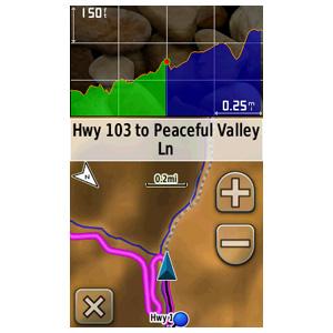
RPires os novos 450, 450T já vem com o gráfico de altimetria. Os 550 podem fazer o download do novo upgrade e também terão o gráfico
Fica assim
a verde o que já se fez e a azul o que falta fazer!!
Hoje fui fazer o trilho do Ermita na Arrábida e pude comparar com o 550 de um companheiro.
O mapa da Ciclonatur é mais detalhado, tem trilhos que não vem no 450T. Mas poucos, aqueles mais fechados e não sei se será apenas em locais onde se concentrem mais bttistas ou em Portugal inteiro, as curvas de nivel do 450T são mais equidistantes mas as da Ciclonatur não contem a informação de elevação!
Hoje constatei algo engraçado, ao seguir o track este indicava os locais onde havia forte inclinação e uma seta a mostrar se era a subir ou a descer, que o 550 não faz. Também não é nada de extraordinário, embora possa dar jeito!
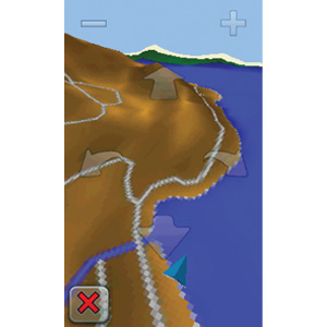
Testei o 3D que para seguir o track não é aconselhado, lento e a visualização nada de especial. Mas dá jeito para locais acidentados onde não há estradas, trilhos para dar uma percepção do que nos rodeia.
Ze Que Cai, eu uso MapSource da Garmin no Mac/Pc e o GPSies na net, há quem use o TrackMaker gratuito, outros o compGPS.
Fica assim
a verde o que já se fez e a azul o que falta fazer!!
Hoje fui fazer o trilho do Ermita na Arrábida e pude comparar com o 550 de um companheiro.
O mapa da Ciclonatur é mais detalhado, tem trilhos que não vem no 450T. Mas poucos, aqueles mais fechados e não sei se será apenas em locais onde se concentrem mais bttistas ou em Portugal inteiro, as curvas de nivel do 450T são mais equidistantes mas as da Ciclonatur não contem a informação de elevação!
Hoje constatei algo engraçado, ao seguir o track este indicava os locais onde havia forte inclinação e uma seta a mostrar se era a subir ou a descer, que o 550 não faz. Também não é nada de extraordinário, embora possa dar jeito!
Testei o 3D que para seguir o track não é aconselhado, lento e a visualização nada de especial. Mas dá jeito para locais acidentados onde não há estradas, trilhos para dar uma percepção do que nos rodeia.
Ze Que Cai, eu uso MapSource da Garmin no Mac/Pc e o GPSies na net, há quem use o TrackMaker gratuito, outros o compGPS.
Last edited: